Saturday, August 17, 2019 didn't look too promising for a microwave dxpedition. Early in the morning, Harry WA0CNS, Herbert AF4JF and Ron KO0Z awoke to thunderclaps and pouring rain. NWS radar indicated precipitation all the way from St. Louis and well past Springfield, IL. Later, Zack W9SZ would become enveloped in rain, which forced him away from his preferred uW location on top of the EN50rl hill top. On the bright side, NWS radar indicated the rain was moving out towards the east (Zack's direction) and the NWS forecast for the remainder of the day would be overcast. Consequently, Ron didn't bring his sun awning with him for Herbert and Harry. Well, the day was partly cloudy and Herbert and Harry have sun burnt faces to attest to the "overcast" skies.
Note AF4JF and WA0CNS, at the gob base, with sunburnt faces after spending the day on top of the EM59ek45 gob knob hill. Darcey, AF4JF's travel companion enjoyed herself.
Despite the rain, Herbert correctly surmised, "We have all day!" Herbert and Harry drove 96 miles in the rain from St. Louis and Ron met them there around 9 am. Ron only had 8 miles to travel to meet them. So, after the threat of lightning strikes abated, we ascended the gob and set up for the contest. A big shout-out of thanks to RECC for allowing us to repeatedly use their gob site with the wind turbine. Thank you! The gob site has a commanding view in all directions and it's perfect for uW activity.
Entrance to Gob Knob EM59ek
Note the wind turbine at the top of the gob site.
Herbert AF4JF and Harry WA0CNS setting up on top of the gob.
Harry WA0CNS has a compass rose which aids him in azimuth location.
Herbert AF4JF is ready for the event.
Darcey, AF4JF's companion, is very interested with Harry WA0CNS
This year, our plan of attack was to use the gob as a focal point and then operate "shoot and scoot" style from various points (pins) 10 miles apart within 20 and40 mile diameter rings from the gob. Ron KO0Z was the shoot and scoot leg of the operation while Herbert AF4JF and Harry WA0CNS remained on the gob top.
The yellow ring indicates the 20 mile diameter and the red ring 40 mile diameter. The yellow pins are potential "shoot and scoot" locations.
Each of the yellow pins are potential operating sites. Unfortunately, Google Maps doesn't indicated if soybeans or corn are planted. Corn is a uW absorber and the op needs to be above the corn. On the other hand, soybeans are not as tall and pose no absorption issues. However, tree rows (windbreaks) as close as 1/2 mile away can block uW signals. So, Ron needed to scout around the pin to avoid corn and windbreaks back towards the gob.
At 10:37 am, Ron made contact with Harry on both cw and phone from a soybean field near the WSMI FM tower site near honey bend. Herbert also made a two-way with KO0Z EM59ef (Pin 1)
The WSMI FM tower is visible in this soybean field 11 miles from the gob location. Nice, strong 10 GHz signals reported both ways. Heading to gob 356 degrees. 10:37 am.
KO0Z's next "scoot & shoot" site (Pin 2) was near Mt. Olive about 21 miles away from the gob. In searching for a suitable location, Ron backed up into a ditch and got stuck. Fortunately, a farm was nearby and thanks to a kind farmer, his John Deere tractor and $20.00, Ron was back on the road, with no apparent vehicle damage, and QRV. He found a site about a mile away from the ditch and made cw QSO's with Herbert and Harry with good signal reports from EM59dc.
Fortunately the farmer was home and aided KO0Z out of the ditch after misjudging the grassy shoulder and backing up into it.
After the ditch mishap, KO0Z made a two-way cw QSO with AF4JF and WA0CNS from Em59dc, another soybean field. Note the trees, KO0Z believes the height advantage of the gob allowed him to make the QSO. 21 mile Q, beam heading to gob 10.2 degrees. 11:48 am.
Scoot & shoot (Pin 3) was between Irving and Witt, IL on IL 16. KO0Z found another soybean field with a good view towards the gob. Good signals, both ways on cw with Harry and Herbert from EM59hf. This contact was 17 miles distant.
Pin 3, EM59hf looking northwest towards the gob, 17 miles away. Man, those are tall beans! 1:03 pm. Heading 317 degrees.
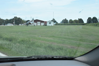
After working Herbert and Harry from Pin 3, pressing on IL 16 towards Witt, Ron encountered a McDonnell Douglas F4 Phantom fighter jet parked in a field!
You don't see that everyday next to an agricultural field. A genuine McDonnell Douglas F4 Phantom fighter jet! This is located just east of Witt, IL on IL 16.
Getting past the F4 unscathed, Ron continued on to Pin 4, Ohlman cemetery EM59ji where he made two-way Qs with Harry and Herbert at 1:46 pm. Excellent signal reports both ways, 20.5 miles away.
Pin 4, Ohlman Cemetery (EM59ji) looking 284 degrees towards the gob, 20.5 miles away. 1:46 pm.
Roving counterclockwise, KO0Z proceeded to Pin 5, just north of Taylorsville, IL. Last December an EF3 tornado struck the town. Some damage is still visible, but the town's done a remarkable amount of cleanup and rebuilding! Again, two-way cw Qs were made with Harry and Herbert, now southwest of my location in EM59io. It's now 2:55 pm.
Pin 5 (Taylorville) looking towards gob, 21 miles away, heading of 238 degrees) Q made at 2:55pm with Herbert and Harry. EM59io.
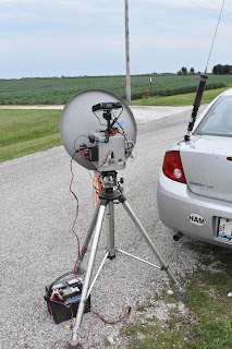
EM59io set-up with my rovermobile and 10 GHz rig. Gotta love soybean fields for uW propagation.
The day is pressing on, I am getting tired shooting and scooting, Harry and Herbert have been slow baking in the sun. Fortunately, the temps were in the mid eighties, but the humidity was high. We decided to skip Pin 6 (New City) and for us to press on to Pins 7 and 8. By 3:40 pm I was at the Auburn site, but it was surrounded by corn, so I found another soybean field between Lowder and Thayer, IL which fit the bill. By 4:10 pm I was set up and we made another Q at 4:17 with the gob with good signal reports on cw.
Corn stalks make great microwave absorbers at ground level.
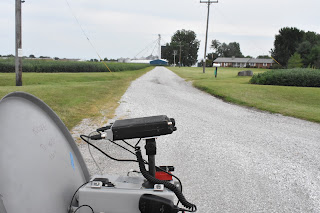
Finally, a suitable uW soybean field between Lowder and Thayer (Pin 7). Qs made at 4:17 pm with good signals on cw. We didn't bother with phone this time. I'm looking southeast (123 degrees, approximately 13 -10 miles away) towards the gob. EM59cn.
I am parked near a mailbox on a one lane gravel road at EM59cn near Thayer.
Sweat bees were abundant everywhere on this uW dxpedition!
Okay, it's almost 4:40 pm and time for one more Q at Pin 8, just north of Carlinville and the dxpedition circle will be complete. Drats! On the way to Pin 8, KO0Z is stopped to wait for a passing coal train to get across IL Hwy 4. 8 minutes later, the crossing gates raise and traffic is moving. KO0Z made the trek to Em59bh, 13 miles away from the gob. Qs were made in cw and phone from this location at 5:10 pm.
A
passing coal train blocks traffic along IL Hwy 4 for about 8 minutes.
Pin 8, Carlinville, EM59bh looking northeast 60 degrees toward the gob site 13 miles away. Great signals both ways.
Another view of PIn 8 near Carlinville.
After Pin 8, it was now time to call it a day. KO0Z rejoined AF4JF and WA0CNS at the gob site, where we fist pumped each other on a job well done. We had some setbacks. Herbert had a stuck relay killing his receive, but he performed a technician's tap and restored it by hitting it on the ground; thereby, freeing up the stuck relay. Harry's radio ended up quitting after 7 hours in the sun. Ron has an intermittent PTT connection that needs tending.
The day was a great success, in spite of some technical difficulties. We know the strategy works, but it will be helpful for the guys on the gob to have two teams out in the field. One working clockwise and the other counterclockwise.
I'll let Herbert AF4JF and Harry WA0CNS share their narratives next!
( Click
here for Herbert's report )


